Today I paid £4 for a month's trial of the premium service on CityStrides and I am already loving it! I'll explain why but first, I'll start at the beginning.
I have been using MapMyWalk for years to map most of the longer walks that I do. This is a free app on my phone it does all that I want it to do in the free version, that is it maps the walks and gives me the total distance and time taken. The screenshot below shows my latest two walks.
For some time I have been using the free version of CityStrides which has been brilliant. The main thing that it does that I love is it pulls together all of the walks collected in MayMyWalk over the years and produces a LifeMap showing all the places that I have ever walked while using the app. (It works with other common mapping apps too.)
Not surprisingly this shows clusters around where I live and in Central London where I like to go walking. It also shows parts of Capital Ring and London Loop though, sadly, I did not always map my walks so there are some embarrassing gaps.
I use my LifeMap a lot when planning walks, I zoom in to the area I plan to walk in and look to see which roads I have walked before and I try to avoid these. If you like exploring as much as I do then new roads are always a better option than familiar ones.
Another thing that CityStrides does for free is show how many roads you have walked in an area. There are 89 areas in my profile and this is the start of that list. The area that I have walked the most of if London Borough of Richmond upon Thames where I have covered just over 50% of the roads.
Another thing that CityStrides does for free is show how many roads you have walked in an area. There are 89 areas in my profile and this is the start of that list. The area that I have walked the most of if London Borough of Richmond upon Thames where I have covered just over 50% of the roads.
All that I have covered so far is available in the free versions of the app.Today I played with the paid (£4 a month) version of CityStrides.
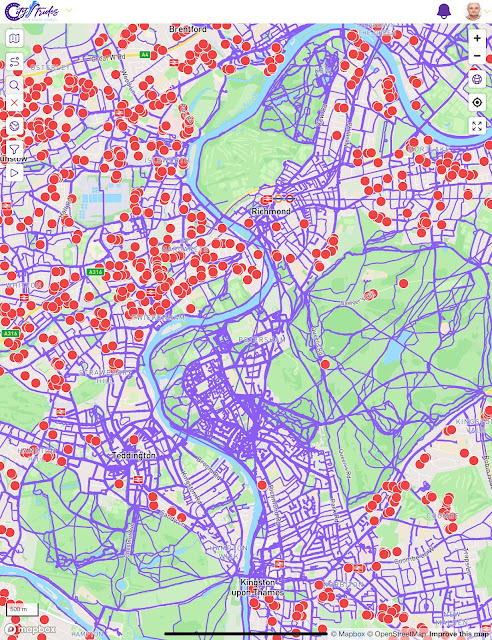
The feature I was most interested with in the premium version is the map showing red dots where roads have not been walked, or not fully walked. This allows me to easily find roads that I have not walked before, especially in areas where I have walked most roads.
At this scale of the picture below it shows the areas of Richmond where I have many unwalked roads. The LifeMap above shows that I have walked many times in these areas and the gaps are things like dead-end roads and side roads in housing estates.
I plan to use this a lot to both plan general areas to walk and then specific roads to walk along. And this is not just about adding more walked roads to my profile, it is about finding new places to explore, every unwalked road has the potential for surprises and delights.
Zooming in further shows precisely where I need to walk to complete the exploration of a road and I was a little surprised to see a few red dots in North Kingston; I will correct those omissions on my walk to the pub this evening!
CityStrides was already a useful tool for a keen walker with its free features and the premium services for paid supporters are a powerful upgrade.


